Manaslu Region
All inclusive cost
All inclusive cost
Manaslu region trekking trail is the eighth highest mountain in the world and is located in the Mansiri Himal, part of the Nepalese Himalayas, in the west-central part of Nepal. Its name, which means “Mountain of the Spirit”, comes from the Sanskrit word Manasa, meaning “intellect” or “soul”. Manaslu was first climbed on May 9, 1956, by Toshio Imanishi and Gyalzen Norbu, members of a Japanese expedition. It is said that “just as the British consider Everest their mountain, Manaslu has always been a Japanese mountain”.
Manaslu at 8,156 meters (26,759 ft) above means sea level (m.s.l) is the highest peak in the Lamjung District and is located about forty miles east of Annapurna. The mountain’s long ridges and valley glaciers offer feasible approaches from all directions, and culminate in a peak that towers steeply above its surrounding landscape, and is a dominant feature when viewed from afar.
The Manaslu region offers a variety of trekking options. The popular Manaslu trekking route of 177 kilometers (110 mi), skirts the Manaslu massif over the pass down to Annapurna. The Nepalese Government only permitted trekking of this circuit in 1991. Manaslu region trekking trail follows an ancient salt-trading route along the Budhi Gandaki river. En route, 10 peaks over 6,500 metres (21,300 ft) are visible, including a few over 7,000 metres (23,000 ft). The highest point reached along the trek route is the Larkya La at an elevation of 5,235 meters (17,175 ft). As of May 2008, the mountain has been climbed 297 times with 53 fatalities.
Manaslu Conservation Area has been established with the primary objective of achieving conservation and sustainable management of the delimited area, which includes Manaslu Trekking.

Day 01: Arrive at Tribhuwan International Airport (TIA) Kathmandu.
You are welcomed by hospitable meeting and then you will be transferred to hotel. Our airport representative will explain briefly the program upon arrival. Overnight at Hotel. B.B.
Day 02: Trek Preparation and Kathmandu Valley Sightseeing Tour.
Sightseeing of world heritage sites in Kathmandu valley including, Kathmandu Darbar square, Swayambhunath Temple, Boudhanath Stupa & Pashupatinath Temple. Overnight at Hotel. B.B.
Day 03: Drive Kathmandu to Arughat (640meters) 8 hours.
Your Trekking staff will come to your Hotel early in the morning at 7.00 am to pick you up; from there we have an 8-hour driving journey to Arughat. From Kathmandu to Dhading Bensi (The district headquarter of Dhading1050m) for 4 hours is comfortable to drive but from there to Arugat for another 4 hours, we will be driving on rough road. Overnight at Tented Camp. B.L.D.
Day 04: Arughat to Soti Khola (775meters) 6 hours.
Along the Budhi Gandaki River toward its point of origin. We pass the village of Morder and Simre to reach Arkhat River. After Arkham ascends slowly toward Kyoropani. Camp today nears the confluence of Seti River – an ideal place to take a fresh water bath. Overnight at Tented Camp. B.L.D.
Day 05: Soti to Machha Khola (900meters) 5.30 hours.
Trail descends slowly until you climb again to mountain ridge to Almara. Pass the forest trail to arrive at Riden Gaon. The valley here cuts into another side of the river to enter Budhi Gandaki. At Lambesi, the trail follows down to the sandy river bed of Budhi Gandaki. Overnight at Tented Camp. B.L.D.
Day 06: Machha Khola to Jagat (1340meters) 6 hours.
After crossing Machha River and Khrola besi, there is a hot spring called “Tatopani”. The trail follows forested area after this toward Dovan. Below Dovan, there is a huge rapid at Budhi Gandaki. As the elevation increases, the rapids and the scenery undergoes a complete transformation. Overnight at Tented Camp. B.L.D.
Day 07: Jagat to Ngyak (2310meters) 6 hours.
After ascending to a terraced hill of Saguleri and view of Sringi Himal (7177 meters) we continue toward Sirish Gaon, Gandaki valley narrows from herewith soaring precipitous walls. Overnight at Tented Camp. B.L.D.
Day 08: Ngyak to Ghap (2100meters) 6 hours.
Follow the trail upstream of Deng River – a tiny village of 4 houses. We walk through a newly built rock tunnel from here, thus avoiding the traditional steep climb. At Ghap, the Tibetan culture begins with Mani stones and chortens all around. Overnight at Tented Camp. B.L.D.
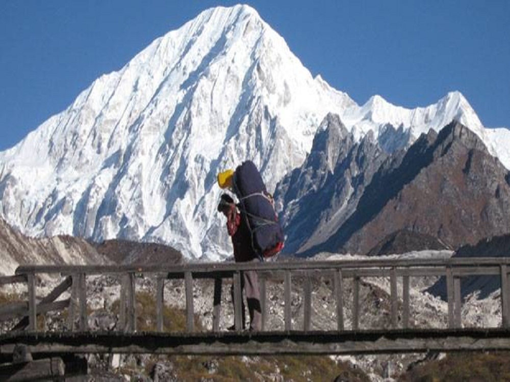
Day 09: Ghap to Lho (3200meters) 6 hours.
After crossing the wooden bridge over Budhi Gandaki we follow the path lined with houses that are interspersed with cultivated fields. At Namru, there is a police check post again. After Namru, across the Hinan river originating from Linda Glacier and continue on to Sho. Naike peak, Manaslu north (7774 meters) and Manaslu (8150 meters) are visible from here. Tonight we camp near a spring at Lho gaon – a small village. Overnight at Tented Camp. B.L.D.
Day 10: Lho to Samagompa (3500meters) 6 hours.
You will pass the stone gate and long Mani stone wall of the village after Lho with full view of Peak 29 ahead. You can make a side excursion to Pungen Glacier from here to get a very close up view of Manaslu. Follow the lateral moraine of Pungen Glacier toward Sama. From the village of Sama, it takes another 20 minutes to reach Sama Gompa for night halt. O/N at Camp. B.L.D.
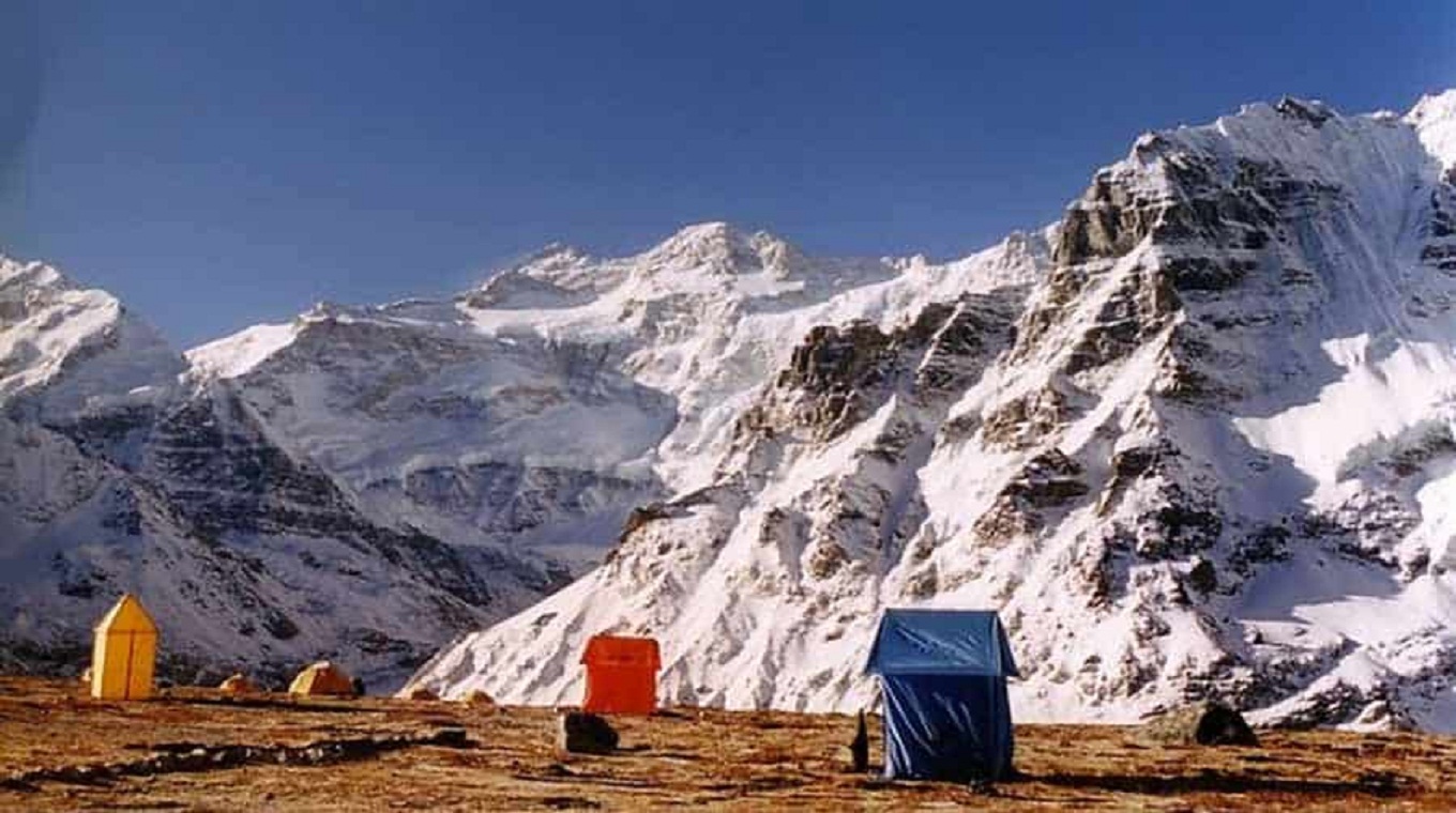
Day 11: Samagompa to Stone Hut (4500meters) 5 hours.
Today we climb a terraced hill on the opposite bank of Budhi Gandaki River from here toward a most remote permanent settlement – Samdo. Here amid the most sever conditions of nature live some 200 villagers in forty houses check-by-jowl. Camp at Stone Hut. O/N Camp. B.L.D.
Day 12: Acclimatization and exploration day.
We will spend a day here in order to acclimatize and adjust to the reduction of the air and also for the local excursion. Overnight at Tented Camp. B.L.D.
Day 13: Stone Hut-Cross Larkya La (5215m) and trek Bhimphedi (3590m) 8 hours.
We first climb towards Cho Chanda and then slowly head steeply uphill towards the snowed-up pass. From the top the panorama is magnificent: Himlung Himal (7126meter), Cheo Himal (6820meters), Gyagi Kung, Kang Kuru (6981meters) and the Annapurna II (7937meters). The descent is steep, through moraines, towards Bhimphedi. Overnight at Tented Camp. B.L.D.
Day 14: Bhimphedi to Tilje (3900meters) 5 hours.
We start with a gentle climb through paddy fields towards the small Karcha La pass and descend through fig tree and rhododendron forests to Tilje. Overnight at Tented Camp. B.L.D.
Day 15: Tilje to Tal (1725meters) 5 hours.
Follow the trail downstream of Marshyangdi River, passing through the scattered villages to reach Tal village for overnight stay. Overnight at Tented Camp. B.L.D.
Day 16: Tal to Jagat (1300meters) 5 hours.
Today the trail runs gently downstream of the river passing the village of Chamje and Himal pani We will have overnight stay at Jagat. Overnight at Tented Camp. B.L.D.
Day 17: Jagat to Besisahar (720m) 6 hours.
Descending gently for 30 minutes and the trail runs gently down to Syange village, and then catch the jeep to Besisahar, Overnight at Tented Camp. B.L.D.
Day 18: Drive back to Kathmandu by bus 7 hours. Overnight at the hotel. B&B.
Day 19: Leisure day in Kathmandu. Overnight at the hotel. B.B.
Day 20: Transfer to the International Airport for your home departure.